GM3-5: Use a co-ordinate system or the language of direction and distance to specify locations and describe paths.
Elaboration on this Achievement Objective
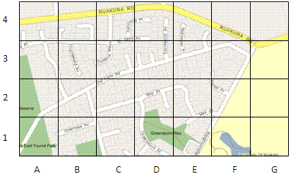
This means students will use co-ordinate systems that are used on maps to specify location and direction (for example Greensborough Reserve is at D1, Ruakura Road runs West-East). The scale of a map indicates distance.
At Level Three students should be able to:
- Give the location of something using co-ordinate references, for example A3.
- Find the location of something given a co-ordinate reference, for example Find Daphne Street at E8.
- Use features of a map to describe movement that would get someone from one location to another, including distance and direction. This includes turns (right, left relative to orientation), main compass directions (N,W,S,E) and approximate distances in metres or kilometres.
- Follow a set of directions given in terms of turns and distances (as above) and show that path they walked on a map of the area.
Teaching resources for this Achievement Objective
Level Three
Geometry and Measurement
Figure It Out activities
This is a level 3 geometry strand activity from the Figure It Out series. A PDF of the student activity is included.
Level Three
Geometry and Measurement
Rich learning activities
The purpose of this activity is to engage students in using grid references to solve a problem.
Level Three
Geometry and Measurement
Figure It Out activities
This is a level 3 geometry activity from the Figure It Out theme series. A PDF of the student activity is included.
Level Three
Geometry and Measurement
Figure It Out activities
This is a level 3 shape activity from the Figure It Out theme series. A PDF of the student activity is included.
Level Three
Geometry and Measurement
Figure It Out activities
This is a level 3 link geometry activity from the Figure It Out series. It relates to Stage 6 and 7 of the Number Framework.
Level Three
Geometry and Measurement
Figure It Out activities
This is a Level 3 Geometry activity from the Figure It Out Series. A PDF of the student activity is included.
Level Three
Geometry and Measurement
Figure It Out activities
This is a level 3 measurement and geometry strand activity from the Figure It Out series. A PDF of the student activity is included.

Level Three
Integrated
Figure It Out activities
This is a level (2+ to 3+) mathematics in science contexts activity from the Figure It Out series. A PDF of the student activity is included.
Level Three
Geometry and Measurement
Figure It Out activities
This is a level 3 activity from the Figure It Out series. A PDF of the student activity is included.
Level Three
Geometry and Measurement
Units of Work
In this unit we use scale drawings to locate ourselves, and other people and objects, in the classroom and in the local community. We also introduce the compass as an instrument that can tell us in which direction we are facing.
Level Three
Geometry and Measurement
Figure It Out activities
This is a level 3 link geometry activity from the Figure It Out series. It relates to Stage 6 of the Number Framework.
Level Three
Integrated
Figure It Out activities
These are level 3 number and geometry problems from the Figure It Out series. A PDF of the student activity is included.
Level Three
Integrated
Figure It Out activities
This is a level 3 number, measurement and geometry activity from the Figure It Out theme series. A PDF of the student activity is included.
Level Three
Geometry and Measurement
Figure It Out activities
This is a level (2+ to 3+) mathematics in science contexts activity from the Figure It Out series. A PDF of the student activity is included.
Level Three
Geometry and Measurement
Figure It Out activities
This is a level 3 geometry activity from the Figure It Out theme series. A PDF of the student activity is included.
Level Three
Geometry and Measurement
Figure It Out activities
This is a level (2+ to 3+) mathematics in science contexts activity from the Figure It Out series. A PDF of the student activity is included.
Level Three
Geometry and Measurement
Figure It Out activities
This is a Level 3 Geometry activity from the Figure It Out Series. A PDF of the student activity is included.
Level Three
Geometry and Measurement
Units of Work
In this unit students use a digital programming platform, Scratch, to learn about polygons, and use the language of direction and distance.
Level Three
Geometry and Measurement
Units of Work
In this unit students use street maps as the context to learn about coordinates and grid references, and for giving and following instructions involving directions and distances.
Level Three
Geometry and Measurement
Problem solving activities
This problem solving activity has a geometry focus.
Level Three
Geometry and Measurement
Figure It Out activities
This is a level 3 geometry activity from the Figure It Out theme series. A PDF of the student activity is included.
Level Three
Geometry and Measurement
Figure It Out activities
This is a level 3 geometry activity from the Figure It Out theme series. A PDF of the student activity is included.
Level Three
Geometry and Measurement
Figure It Out activities
This is a level 3 geometry activity from the Figure It Out theme series.
Level Three
Geometry and Measurement
Figure It Out activities
This is a Level 3 Geometry activity from the Figure It Out Series. A PDF of the student activity is included.
Level Three
Geometry and Measurement
Rich learning activities
The purpose of this activity is to engage students in using mathematical constructions to locate a position on a topographical map.